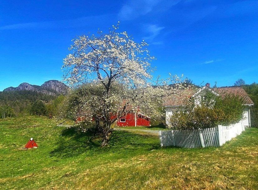
Flekkefjord
The Best of Southern Norway
Norwegian Travel Workshop 2023

Flekkefjordbanen
Welcome to Flekkefjordbanen and our rail biking trips! This is a perfect activity, whether you are visiting with your family, a group of friends, or are ready for a teambuilding day with your colleagues.
The rail bikes are custom-made and specifically designed for comfortable and safe cycling on railway tracks. Each bike has room for two people cycling, as well as one adult passenger or two children. The bikes are versatile, practical, and flexible, and can easily take wheelchairs and child seats.

Explore Flekkefjord
Experience the history of the Dutch period (16th and 17th centuries) and enjoy the exciting street art that is found around the whole city. The contrast between old and new gives you new and exciting experiences every time you visit Flekkefjord!
For many years, national and international street artists have decorated our city. The city’s street art has created a lot of buzz and the locals are proud of their art. The art has adorned several walls in the historic part of the city.

StreetART
in Flekkefjord
StreetART Flekkefjord started in 2015. Since then, more than 30 exciting works of art have been spread around the city. Walk through the city centre, and enjoy its small and large wooden houses, while you experience our amazing outdoor gallery.
For many years, national and international street artists have decorated our city, making it a sparkling piece of art itself. You can also find street art on Google Maps by searching for “Street Art Flekkefjord” Enjoy!

Island magic at Hidra
In order to get to the gorgeous island Hidra, you need to go on a 10-minute ferry ride. The ferry pier is located close to Flekkefjord. Hidra has about 600 inhabitants and is a popular place to visit for both Norwegians and international visitors. Check out the charming outposts, go bathing, or fishing amid idyllic islets and reefs. Hidra has been inhabited for thousands of years. Vikings used to live there. In the 19th century several gold items and runes were found on the island.

Moonwalking at Brufjell
You might have seen it already. It is the most popular selfie spot in Southwestern Norway. Brufjell, or the potholes at Brufjell (Brufjellhålene) are all over social media! It is THE place to make that iconic selfie with your friends or family. But a lot of people are unaware that the striking rock formations you see there are made of anorthosite which is the same rock that you find on the surface of the moon. So at Brufjell you can literally walk on the moon!
Walking from Roligheten to Brufjell you will get an amazing panoramic view of the open ocean. The potholes at Brufjell were created due to erosion. That is, the ocean and pepples created these magnificent stone formations after the last Ice Age. This kind of potholes is a very rare natural phenomenon.
The outer path, which has a red trail mark, has a section that is very steep. Walking along this trail, you have to be very careful. From Brufjell you can get into the potholes at Brufjell (Brufjellhålene). The path down to the potholes is very steep and you need some strength in your arms and legs, to master this trail. Steel hoops have been installed to climb on the steepest section (a short via ferrata without rope securing). We recommend that you only do the steep path when the mountain is dry.

Picturesque Egersund
Experience the historic town of Egersund: A cosy town filled with historic wooden houses and a beautiful centre with many restaurants, cafes and niche shops. All this and more only an hour from Stavanger.
Egersund city has one of the best preserved wooden houses in Norway. Large parts of the urban area are now regulated as historical special areas. Many fine examples of wooden houses can be found in the street Strandgaten, which was previously the city's main street. It was created after a regulation in 1843 when a large fire left several buildings in ashes. During the reconstruction, the outer district had straight streets in a smooth grid pattern. Haugen - Egersund's "medieval town" - is also worth a visit.
Today, there are small specialty shops side by side in cosy pedestrian streets. You can walk on your own among up to 160-year-old wooden houses using the city walking brochure or use your mobile as a guide: download the app 'Magma Geopark' and take the trip Strolling in Egersund (Norwegian and English). Also, try the new cultural trail with city history signs - a route with 14 signs in the middle of the old wooden houses. The cultural trail is suitable for everyone who wants a cosy walk at the same time as they get a little better acquainted with Egersund centre. End the trip by going up to Varberg and the rock carvings. After a city walk, you can visit the Faience Museum.

Trollpikken
Trollpikken is a unique stone formation near Egersund that became world-famous in June 2017, when it was cut off during the night. Money was raised to get Trollpikken back in position. Two weeks later it was safely back. This spectacular, phallus-shaped stone has got the name Trollpikken. Be an adventurer, put some food in your backpack and get your legs moving to this funny-shaped stone formation. 25,000 others did so in the year of 2017. An adventurous trip of 2.3 kilometers each way is suitable for happy walkers along the asphalt, gravel road and path.

Idyllic Sogndalstrand
Sogndalstrand is located 30 kilometres south of the town of Egersund, and was an important seaport in the days of sail. In these idyllic surroundings, you will find Sogndalstrand Kulturhotell in its newly restored wood laggings from the 1800s. Here, all visitors are welcomed with great hospitality.
In the old village Sogndalstrand - you'll find Sogndalstrand Kulturhotell. In its newly restored wooded cladding from the 19th century, the hotel staff receive travellers with warmth and kindness. The ancient buildings are buzzing with life again. An extraordinary hotel - open for accommodation, conferences or perhaps as a frame for that special occasion.
Sogndalstrand was originally an old rest stop from the sailing ship era. In this idyllic environment, you will find Sogndalstrand Kulturhotell in a newly restored wooden suit from the 19th century. Here, travellers are received with warmth and great hospitality.

Helleren / Jøssingfjord
The dramatic landscape seen at Jøssingfjord and Helleren seems to be a magnet for many tourists. At Helleren two houses were built close to the mountain. The mountain creates a natural roof and shelter, which humans have lived under for millennia. It is a massive rock formation, with water dripping from heights of up to 10 meters. The roofs of the two houses are unthatched, as they are protected by Helleren. The two houses stem from the 19th century, but parts of the buildings are likely to be older. People have presumably lived in the area since the 16th century.

Bjerkreimselva
Bjerkreimselva (the river of Bjerkreim) is a popular area for fishing salmon and sea trout. It is rated one of the best salmon rivers in Norway. Several years the total catch in the river has been more than 7 000 salmon! Salmon fishing between 15 June and 20 September, fishing licenses are available at Esso Vikeså Veiservice, Cirkle K or at Bjerkreim Elveeigarlag / Bjerkreim Camping. See www.bjerkreimselva.no for more information. Some fishing equipment are available for sale at Coop Marked Vikeså and Coop Marked Bjerkreim. Fishing spot on Gjedlakleiv right by E39 is wheelchair accessible.

Gloppedalsura
Gloppedalsura is the largest stone scree in Northern-Europe. It consists of enormous landslide rocks scattered over a moraine. An end moraine is a flat area of loose material that is located at the bottom of a glacier during a period when the glacier retreats.
Frost blasting set enormous forces in motion More than 10,000 years ago the glaciers in the area melted, and a large end moraine dammed up the Hunnedalselva river towards Veen and Vikeså, and thus a lake formed in Byrkjedalsgryta. The next period of freezing caused an avalanche of enormous blocks of stone on the southern side of the mountain.

Gursli Mines & Hattesteinan
Molybdenum mining at Gursli took place from 1915 to 1919. Molybdenum is a metallic element that was mainly used to strengthen and harden steel. The mine at Gursli was active to supply molybdenum for steel production during World War I.
Visiting Hattesteinan, the first half hour is uphill where you get an amazing view of the area. A short distance up the hill, a panoramic view of lake Lundevann appears in the horizon. The lake stretches all the way from the centre of Moi to Åna Sira. Lundevann is one of the deepest lakes in Norway.

Lund Bygdemuseum
Lund municipality has a rich and exciting cultural and industrial heritage, with old homesteads, furniture factories to abandoned mines in scenic surroundings. Lund Bygdemuseum and Kulturbank manage, preserve and share their cultural heritage to the local population, and other visitors.
The museum is located in the old rectory barn about 300 meters from the centre of Moi. Here you will find numerous collections that cover most of the history of Lund municipality.